
Sensors can be divided up based on form of wavelength. A standard camera captures the reflection of solar radiation. For terrestrial radiation to be measured passive microwave provides good results. It gives thermal properties to materials, and interpreted it reveals surface materials, vegetation, moisture and sea surface temperature. Active remote sensing, such as RADAR or a camera with a flash, provides its own source of energy to illuminate the scene.
Electromagnetic Radiation
Sensor data is created by an instrument receiving and recording EM radiation reflected or emitted from objects in a field of view. EM energy is generated by the changes of energy levels of electrons, acceleration of electrical charges, the decay of radioactive substances and the thermal motion of atoms and molecules. Nuclear reactions within the sun generate a wide spectrum of EM radiation and travels through space with little change. (Campbell, 1996) EM waves are different than water or vibration waves, in that there does not need to be a medium for their propegation. Sensors provide pictorial veiws of a landscape as well as measurements about particular variables such as cloud height.
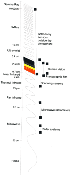
EM radiation and the sensitivity range of remote sensing systems (Wilkie, et al., 1996)
Photographic Sensors
The idea that a picture is worth a thousand words is validated by the large amount of spatial information that they present. The spatial layout represents interrelationships, sizes and positions within a space. Utilizing the electromagnetic (EM) spectrum further than the human eye can see by recording emitted or reflected EM energy, provides extra information of great importance to the study of our planet. Imagery data can then be further analyzed by computers utilizing statistics and other numerical methods. By transforming the sensor data, the analyzed data can be turned into extracted information.
Photographic sensors using film and lens were initially used in balloons in 1850 (Campbell, 1996), and was later used in 1909 in airplanes and later in satellites, but has now gone the way of the beta VCR, because of the difficulty of film retrieval. They are now replaced with charge-coupled devices (CCDs), that convert photons to electrons and record received values on shift registers. The data is then transferred to long-term storage or is downloaded to a ground based server. Once on the server the data is in raster format, which is a two dimensional image of various intensities received.